Parish Heritage Trail
This Heritage Trail is part of our project "Revealing St Alban's Hidden Heritage" supported by a grant from The National Lottery Heritage Fund, thanks to players of The National Lottery.
![]()
Begin your tour outside the west door of the church ❶. There is now an open area opposite the church. Before the housing clearance of the 1950s and 60s, this was a densely populated area of crowded terraces, courtyards and back-to-back houses.

Victorian Housing on Conybere Street
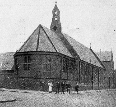
The Grade II* listed Victorian Gothic Church of Saint Alban the Martyr opened in 1881. The tower and spire planned by the architect, John Loughborough Pearson, was never completed; instead a tower was added in 1938 to a different design by local architect E.F. Reynolds with a distinctive saddleback roof.

J.L. Pearson's Design with Tower and Spire
The tall Celtic cross in the church garden on the corner is a memorial to the brothers James Samuel Pollock and Thomas Benson Pollock, founders not only of the two churches of St Alban and St Patrick but also of the first schools in the parish.
Turn the corner into Conybere Street and go uphill past the church tower, where a Birmingham Civic Society plaque commemorates Birmingham artists Kate and Myra Bunce, who made and gave the fine altarpiece inside the church.

Continue up Conybere street. On the right, James Samuel Place and Thomas Benson Place behind it are named for the Pollocks. Beyond the church are Grade II listed former Lench’s Trust Alms Houses ❷ of 1879 by J. A. Chatwin, now St Basils Conybere Gardens, housing young people.
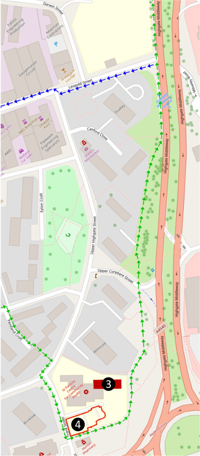
Once past the Alms Houses, turn right into Pentland Croft. At the end, follow a footpath heading between the 1960s Wilmcote and Brinklow Tower Blocks, to reach Upper Highgate Street. Ahead, to the left, the red brick building ❸ behind St Patrick’s Centre for Community Health was St Patrick's church school. Built in 1933 to replace an earlier school building on the same site, it closed in 1983.
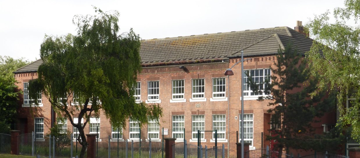 St Patrick's School
Cross the road into Frank Street. Stop by the carpark for the health centre ❹, the site of St Patrick’s Church (red outline on the map). Designed by J.L. Pearson, St Patrick's opened in 1896 as a daughter church of St Alban's. It was demolished in 1966 and the parishes were united.
 St Patrick's Church
Ahead is Belgrave Middleway, part of the ring road, and the parish boundary, but turn left onto the footpath between the carpark and Hingley Pharmacy.This path follows the line of the vanished Highgate Brook, which was the original parish boundary between Aston and Kings Norton, and also between Warwickshire and Worcestershire.
Bear left to follow the ring road, here called Highgate Middleway and again the parish boundary. Continue for 400m / 430 yd, crossing the mouth of Upper Conybere Street (the street sign says only "Conybere Street"), to reach Leopold Street on your left. Here you have a choice.
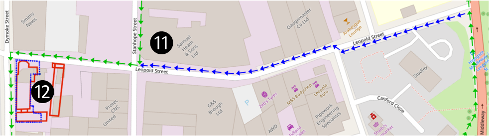
For the shortest tour, turn left down Leopold Street, passing brass founders Samuel Heath & Sons ⓫, founded in 1820. Cross Stanhope Street and when you reach Dymoke Street, continue at ⓬.
For the full tour, continue 130m / 145 yd along the Middleway and fork left into Moseley Road, then right into Stratford Place to view Grade II* listed Stratford House ❺. Built in 1601, this was originally a prosperous farmhouse.

Here again you can shorten your tour. To do so, turn your back on Stratford House, cross the grass, join Moseley Road and continue at ❾.
For the full tour, continue along the front of Stratford House, cross New Mosely Road and rejoin the ring road. At the roundabout take the first exit for Camp Hill.

Turn left into the top of Ravenhurst Street (pedestrian access only) to view the Grade II listed Ravenhurst Cottages ❻. Opened in 1848 by Lench’s Trust as Alms Houses, they now provide accommodation for homeless young people.
Return to Camp Hill and continue, passing a Seventh-day Adventist Church on the other side of the road, towards traffic lights at the corner with Bradford Street. Here look across the road through the trees to the slate-roofed yellow stone church. This is Holy Trinity, Bordesley ❼, opened in 1822 as a chapel of Aston Parish for this district as Birmingham grew rapidly in size. It received its own parish in 1864.

Holy Trintiy, Bordesley
It was the second vicar of Holy Trinity, Dr Oldknow, who invited James Pollock to start St Alban’s Mission in 1865 in Vaughton’s Hole, a poor corner of his parish undergoing rapid development with a mixture of industry and poor housing. His successor, Fr Richard Enraght, contemporary and friend of James and Thomas Pollock, was famously imprisoned in November 1880 for High-Church practices, made illegal by the Public Worship Regulation Act of 1874. This act was promoted by Archibald Campbell Tait Archbishop of Canterbury with the backing of Prime Minister Benjamin Disraeli, who called it "a bill to put down ritualism", at a time of hostility to both Roman Catholicism and the Oxford Movement. Fr Enraght was released from Warwick Gaol in January 1881, but subsequently evicted from his position at Holy Trinity in 1883.
In 1883 Archbishop Tait was succeeded as Archbishop of Canterbury by Edward White Benson, who stopped further prosecutions, though the Act was not formally repealed until 1965. Archbishop Benson was born in Lombard Street, where a Birmingham Civic Society Blue Plaque commemorates the site, which is now in our parish, though at the time it would have been part of the district of Deritend. Before becoming Archbishop, Edward Benson was Bishop of Cornwall and was responsible for begining the building of Truro Cathedral. Its architect, John Loughborough Pearson, designed it at the same time as St Alban's Church.
Holy Trinity closed in 1971. For a time it served as a shelter for homeless men, but has been unused since about 1999.
If you wish, you can cross the road for a closer look at the church, though access is not possible. To do so safely, first cross Bradford Street to the triangle by the pedestrian crossing lights, then cross Camp Hill in two stages by the pedestrian lights and finally cross Old Camp Hill (the current parish boundary). Return to the corner of Bradford Street.
Continue down Bradford Street past Broom Street to reach Moseley Road on the left.
For the standard tour, turn left into Moseley Road, passing the Moseley Arms ❽, a Victorian Public House on the corner of Ravenhurst Street. Follow Moseley Road as it curves left past Highgate Park and continue at ❾.
As a web-only bonus, not in the printed leaflet, here you can extend your walk by 500m / 540 yd to see St Anne's Church, Rowton House and St Anne's Hostel.

To do so continue down hill past ⓰ 132 Bradford Street, a Grade II listed late eighteenth century red brick two bay town house of three stories (the ground-floor brickwork is covered by early ninteenth century stucco), followed by ⓱, a substantial three story Victorain building 123 - 131 Bradford Street, now Bradford Court Business Centre. Pass Rea Place and continue to Alcester Street (the parish boundary) and turn left. On the other side ot the road is ⓲ St Anne's Roman Catholic Church. St Anne's Church was founded by John Henry Newman when he came to Birmingham in 1849, before his move the the Oratory on Hagley Road, Edgbaston. The present church dates to 1884, designed by London architects Albert Vicars and John O'Neill and is a Grade A locally listed building. It was here that J.R.R. Tolkien worshipped when he lived in Moseley.
Continue along Alcester Street past Cheapside to Moseley Street. The Large building on the opposite side of Moseley Street ⓳ is Rowton House, a very substantial Grade II listed Edwardian building opened in 1903 to provide cheap, clean accommodation for low-paid working men. The first Rowton House opened in London in 1892, financed by philanthropist Lord Rowton. Soon there were five more in London, and the Birmingham example was built by a local company, to the design of Harry Bell Measures, architect of the London examples. Originally there were cubicles to accommodate 819 men at 6d (2.5p) per night; by 1973 there were 500 beds at 65p per night. In the 1990s it was refurbished as a modern hotel, named The Paragon Hotel, but has since reverted to the name Rowton Hotel.
Go up Moseley Street past ⓴ 112 Moseley Street, a Grade II listed Victorian former police barracks of about 1880, now home to St Anne's Hostel founded in 1976 as a hostel for homeless men and their dogs by one of the priests of St Anne's Church. At the time of wrtiting the block on the other side of Moseley Street has been demolished prior to redevelopment.
On reaching the junction cross Moseley Road, turn right, and continue at ❾.
Continue as Moseley Road curves left past Highgate Park, to view numbers 90-118, ❾ Grade II listed villas built from 1820 to 1855. Here on the higher ground richer people bought plots to build their homes on the edge of Birmingham. Cross the road and return to the entrance of Highgate Park. Enter park and fork slightly left to cross the park ❿ by a tree-lined avenue with benches on each side.

This park originated from four fields given in 1790 in the will of Elizabeth Hollier to a Trust that was to provide clothing for 24 poor people each year from the rent for grazing rights. The old field boundaries are marked in red on the map. By 1875 they were the only green space left in the parish and the Trustees of Hollier's Charity wanted to develop the land for building, but instead Birmingham City Council bought them for a public park.

The four fields in the 1833 Aston Tithe Map
On leaving the park, turn right. At the end of the road turn left following a footpath beside railings to reach and cross Darwin Street. Follow Stanhope Street to Leopold Street, passing on your left ⓫ the brass foundry of Samuel Heath & Sons, founded in 1820. Turn right down Leopold Street to reach Dymoke Street.

The corner plot on the left ⓬ was the site of the original St Alban's Mission building on Leopold Street, opened in 1865, and the first ʻpermanentʼ church building, opened in 1871 beside it on Dymoke Street. These are outlined in red on the map. When the present church opened in 1881 the old church was converted for use by St Albanʼs school.
The 1871 Church with Windows Enlarged for School Use
In 1915 it was replaced with a purpose-built school, outlined in blue, designed by architect John Goodman, a churchwarden of St Alban's Church. There was a playground on the flat roof to make best use of the small plot of land.

The 1915 School Building on the Corner of Leopold Street and Dymoke Street
This building was demolished after the school moved in 1965 to a building opposite the present church, in turn demolished when the school, now an Academy, moved in 2013 to a new building. The site was sold and the proceeds used to endow a small charity, The Trustees of St Alban's School.

Turn left into Dymoke Street. When the road turns left, continue ahead to reach Angelina Street with the new Academy building ⓭ ahead of you, strikingly clad in stripes of red, brown and orange. Turn right and follow the road as it swings left, then take the footpath to the right of the ramp, following the fence of Chandos Primary School. When the path forks, go right then left, to walk beside the River Rea to the bridge carrying Gooch Street over the river. ⓮ This is the site of the original “Vaughtonʼs Hole”, where until about 1831 a floodgate held back the river to divert water into the ʻflemʼ an artificial channel along the line of Gooch Street that fed a mill in Digbeth. By the 1860s the name was applied to a nearby clay pit and brickworks and generally to the whole lower part of Highgate, while the higher ground was "the hilly fields".

A Sketch of the Floodgate at Vaughton's Hole in 1831
Turn left up Conybere Street past St Albanʼs Academy ⓭.
On your right, Highgate Baptist Church ⓯ carries a blue plaque commemorating the Rev. Peter Stanford, an African American born into slavery, who became Birminghamʼs first black minister in 1889 at the earlier Baptist Church in Hope Street. Continue up Conybere Street to return to your starting point ❶.
We hope that you have enjoyed our heritage trail and learnt something new about the history of our parish.
The maps for this trail are based on OpenStreetMap.